A Field Edge, a Lane and a Gate: Reading a Rural Boundary
Read a rural boundary by distinguishing a field edge, lane and gate, so you can understand what guides movement and check access before choosing a route.
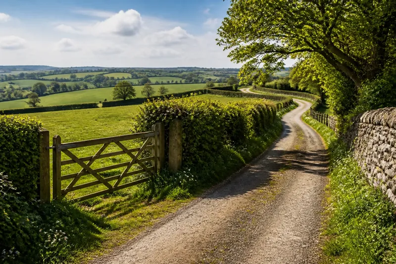
The common mistake when reading a rural boundary is to treat every visible line as a path. That can lead you to a closed gate or an unmarked field edge, while the route you may use continues elsewhere. To read a rural boundary, distinguish the field edge, lane and gate before deciding where to walk.
Ask three questions: what marks the edge of a parcel, what provides a route, and what controls passage between them? A hedge may divide fields, a lane may carry movement, and a gate may close an opening. Their proximity does not mean they have the same purpose or access status.
What does each feature tell you?
A field edge is a visible or physical limit to a cultivated, grazed or otherwise managed area. It may be a hedge, stone wall, bank, ditch, fence or change in vegetation. Read it as a boundary first, not as a route. A narrow strip beside it may look walkable, but appearance alone does not establish a right to use it.
A lane is a corridor of movement. Its surface may be tarmac, gravel, packed earth or grass, and its width can vary. Notice its continuity, entrances, signs and connections with adjoining routes. A lane may serve farms, homes, pedestrians or several kinds of traffic; its appearance does not settle who may use it.
A gate is an opening in a boundary that can be closed or controlled. Its hinges, latch and position show how people or animals might pass, while the adjoining fence or wall shows the boundary it interrupts. A gate may stand on a public route, private drive or working field entrance. Its presence does not prove public access.
To check permission, consult relevant route information, such as a suitable local map, signs, posted notices or information from the landowner or local authority. If the status remains unclear, stay on a route you know you may use and seek reliable local guidance.
How can you read a rural boundary on a walk?
Choose the approach that matches what you want to understand. You can observe features from a lawful place without crossing a boundary or approaching livestock.
- Read the edge: From a route you may use, note the boundary’s material, condition and changes. If a hedge and ditch run together, then treat them as clues to the field division, not as evidence of a path; if you need to confirm the route, check a map or local information instead.
- Read the lane: Trace its direction and where it meets tracks, road junctions or entrances. If it connects clearly to a marked route, then follow the route information; if its status is uncertain, do not infer permission from a worn surface and check before proceeding.
- Read the gate: Observe which boundary it closes and whether route signs or markings reach it. If a marked path is shown through the gate, then follow the posted guidance; if there is no clear route information, remain on the route you know you may use and seek local guidance.
Say you are standing on a marked public lane beside a hedged field. A narrow opening contains a closed gate, but you can see no route marking beyond it. You check the local path map and find that the marked route continues along the lane rather than through the opening. The resulting decision is to stay on the lane: the gate appears to serve a field entrance, not the route shown on the map.
Which clues help distinguish a boundary from a route?
Use several clues together. No single feature reliably explains both the purpose of a line and who may use it.
- Continuity: A route often leads towards another route or destination, while a field edge may turn around a plot. If a line follows the shape of a field, then read it as a possible boundary; if it continues towards a mapped route, check that route information before following it.
- Surface: A worn, compacted or surfaced strip may suggest repeated movement, but not public access. If the strip is unmapped or unmarked, then do not treat wear as permission; use a route with clear access information.
- Construction: A hedge, wall or fence commonly marks a division, and a gate indicates a controlled opening. If the gate has route signs or appears on a reliable map, then check their wording and follow applicable guidance; if not, do not assume you may pass.
- Connections: A lane may join another route, reach a building or end at a field entrance. If it connects to a marked public route, then follow the mapped route; if it leads to a private-looking entrance and its status is unclear, check before proceeding.
- Signs and markings: Read notices and route signs from a safe, lawful position. If a sign gives clear access guidance, then follow it; if signs are absent, unclear or conflict with map information, pause and seek reliable local advice.
- Use and upkeep: Wheel marks, clipped vegetation or a clean latch can suggest recent activity or maintenance. If you see these clues, then treat them only as signs of use; if you need to decide whether to enter, rely on route information instead.
What do walkers ask about a rural boundary?
Does a gate mean there is a public footpath?
No. A gate can serve private land, a farmyard or a route with particular access rights. Check a suitable local map or posted information before treating it as a public way.
Is a grassy strip beside a hedge a path?
It may be a route, a field margin or uncultivated ground. Look for route information, and do not infer permission from a worn appearance alone.
How can I tell a lane from a farm track?
Surface and width are not decisive, since either can vary. Check signs, connections and route information to establish access rather than relying on the track’s appearance.
What should I do if a gate is closed?
Do not climb it or assume it should be opened. If you are on a marked route, follow its stated guidance; if you are not sure whether the route continues, stay on a route you know you may use and seek local information.
How do these features shape the landscape?
The field edge gives a walk a sense of limit. A high hedge can narrow the view, while a low wall or open ditch may leave more of the adjoining land visible. These boundaries can make a route feel sheltered or exposed, depending on their height, gaps and surrounding vegetation.
The lane shapes pace and direction. A firm surface may be easier to follow than a faint track, while bends and junctions call for closer attention. A lane can link a settlement to scattered homes, fields or working entrances; those connections help explain its place in the landscape.
The gate makes a change between spaces visible. A latch, sign or change in surface may mark a transition between a public route and managed land, or simply divide parts of a working landscape. Physical access and permission are different questions, so read the boundary without assuming the opening is yours to use.
How should you choose what to follow?
Start with your purpose, then check access before following an uncertain line. For landscape observation, you can study boundaries from a route you may use. For a walk, use route information and signs; treat unmarked openings with care.
At a junction of lane, field edge and gate, identify each separately: trace the boundary, follow the route information and read the gate as a control point. To read a rural boundary safely, observe where the field line continues without crossing it; that detail can help you understand how the landscape is divided while keeping your route clear.