A Ridge and a Valley Tell Different Route Stories
Learn how to read ridge and valley routes from contours, slopes and crossings, so you can interpret a map without assuming terrain dictates every road.
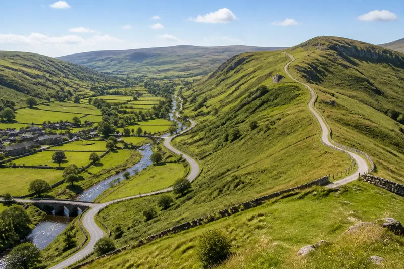
The common mistake when reading a rural map is to treat every road as a direct response to the nearest hill or stream. That can make a valley road look inevitable and a ridge road seem surprising, when both may reflect a mix of terrain, settlement and access. Ridge and valley routes do tell different broad stories: one often follows a relatively continuous line of high ground, while the other may trace a floor, a stream or a chain of crossings. Read those patterns as clues, not rules.
Are you looking at a broad route pattern?
Start with the shape of the land before asking why a particular road bends. On a contour map, close contour lines mark a steeper slope; widely spaced lines suggest gentler ground. A ridge appears as a high strip or spine, while a valley forms lower ground between rising sides. A shaded relief map can make those forms easier to see, but contours help you judge where the slopes change.
At this scale, look for continuity. Does a track or road run along a long crest, or does it keep to low ground beside a watercourse? Does it cross a ridge at a low saddle, or leave the valley at a gap between slopes? These alignments suggest the terrain a route tends to favour. They do not identify who built it, when it was made or what purpose it served.
For a broad comparison, use a topographic map and follow the route for a while in both directions. A single bend may be shaped by a farm, a bridge or a property boundary; a longer alignment is more useful for spotting a relationship with the land.
Does your route run along high ground?
If you see a route that holds to a ridge or shoulder, read it as a way of using a continuous strip of higher ground. A crest can offer a connected line between places without requiring the route to descend into every hollow. The actual road may sit just below the highest point, where the slope is less abrupt or the ground offers a suitable approach.
Look for changes in the ridge’s form. A broad, gently sloping back may carry a straighter route than a narrow crest with sharp drops on either side. At a dip, a road may cross to another high strip; at a steep spur, it may turn towards a saddle rather than climb directly. These are useful map observations, not proof of a particular construction decision.
Ridge routes can also be interrupted. A road may descend towards a village, a crossing or a junction, then climb again. Buildings, field access and links to lower routes can explain a break in the line better than the shape of the ridge alone. Check the surrounding map for those connections before describing the road as a simple crest route.
If the map is your only source, say “follows high ground for part of its course” rather than claiming the route runs along the ridge from end to end.
Does your route stay on a valley floor?
When a road follows low ground, compare it with the stream and the valley sides. It may run beside the water, but it can also keep to a drier terrace or skirt the foot of a slope. A valley floor is not a single line: it can include wet ground, level ground, meadows, settled areas and the narrow corridors where a route can pass.
Watch for places where the valley narrows. The road may shift from one side to the other, bend around rising ground or meet a bridge where a tributary joins the main stream. A route that appears to follow water on a small-scale map may sit some distance from it on the ground. At larger scale, compare the road, stream and contour spacing instead of assuming they share the same course.
Valley routes often connect several kinds of place: settlement, crossing, farm access and junction. That makes their pattern less uniform than a line along an open valley might suggest. If a road leaves the floor for a hillside, look for a spur or a gap that offers a way out, but leave room for other explanations such as access to a place that is not shown on your map.
Are you comparing a crossing or a route out of the valley?
Choose this lens when the route changes direction near a stream, a steep slope or the edge of a valley. The important clue may be a crossing point or an exit from low ground, rather than the route’s overall alignment. Look for bridges, ford symbols where shown, junctions, contour gaps and roads that climb towards a neighbouring ridge.
Crossings can draw routes together because a stream interrupts travel across the valley floor. Yet a bridge’s position may also reflect settlement, land access or a convenient meeting of routes. A map can show where a crossing is, but it cannot always explain why that particular point was chosen.
Why does a road leave the valley floor?
It may climb towards a ridge, a saddle or a settlement on higher ground. It may also follow a spur that offers a gentler line up the slope, so check the contours rather than reading the climb as a straight ascent.
Why does a road cross the ridge at a dip?
A saddle is a lower point between higher parts of a ridge, and the map may show a route passing through it. Treat that as a terrain clue: the route may use the dip, but the map alone cannot establish the full reason for its location.
Does a streamside road always follow the valley floor?
No. It may use a terrace or the edge of the valley, while the stream bends through lower ground. Compare the road’s position with contours and watercourses at a scale that makes those differences visible.
Can a ridge road connect with a valley route?
Yes. Roads often meet where a slope, spur or settlement brings routes together. Follow each branch away from the junction to see whether one holds high ground and the other follows the valley.
Is the terrain pattern clear enough to interpret?
Use the map type that answers your question. A regional road map helps you see longer alignments and connections between places. A topographic map is better for contours, saddles and valley sides. An aerial image can show the visible course of a lane, though trees and buildings may hide the terrain beneath it.
Then separate what you can see from what you infer. “The lane runs beside the stream” is an observation if the map shows both clearly. “The lane was built there to avoid steep slopes” is an explanation that needs evidence beyond the alignment. This distinction keeps a useful reading from turning into a story the map cannot support.
Imagine you are tracing a lane from a low-lying village towards a ridge. It follows the stream for a stretch, bends at a tributary and then climbs through a gap in the contours. You can describe the observable pattern as a valley approach followed by a climb through a saddle; you should not claim that the saddle was chosen for a particular historical reason unless another source supports that account.
For a walking route, terrain interpretation is not a substitute for current route information. Check access, surface and conditions through suitable local sources before setting out, especially where a mapped line crosses private land or difficult ground.
What fits your situation?
- You want to describe a regional pattern: follow several roads across the map and note whether they tend to hold high ground or low ground. This fits a broad landscape reading because repeated alignments matter more than one bend.
- You are explaining one road: inspect its immediate slopes, crossings, junctions and nearby settlement. This fits a local reading because small features can redirect the route.
- You are comparing a ridge and a valley: use the same map scale for both, and describe the ridge as a high-ground corridor and the valley as a low-ground corridor. This makes the contrast clear without pretending either has a single standard form.
- You are deciding where a route crosses or climbs: look for bridges, tributaries, saddles and gentler spurs. This fits a terrain-focused question, but treat each feature as a clue rather than a complete explanation.
- You are unsure whether the map supports your claim: use cautious wording such as “appears to follow” or “crosses near”. This is the right choice when a map shows alignment but not the route’s history or purpose.
The useful search phrase is ridge and valley routes: it points to a contrast in broad alignment, not a rule that every road must obey. Read contours, watercourses and junctions together, then state only what the map lets you see. A ridge may guide a route along high ground; a valley may gather routes around its floor and crossings, while the details remain specific to each place.